Manaslu Four High Passes Trek

Manaslu Four High Passes Trek

Manaslu High Passes Trek


Manaslu High Passes Trek – Ultimate Himalayan Adventure in Nepal

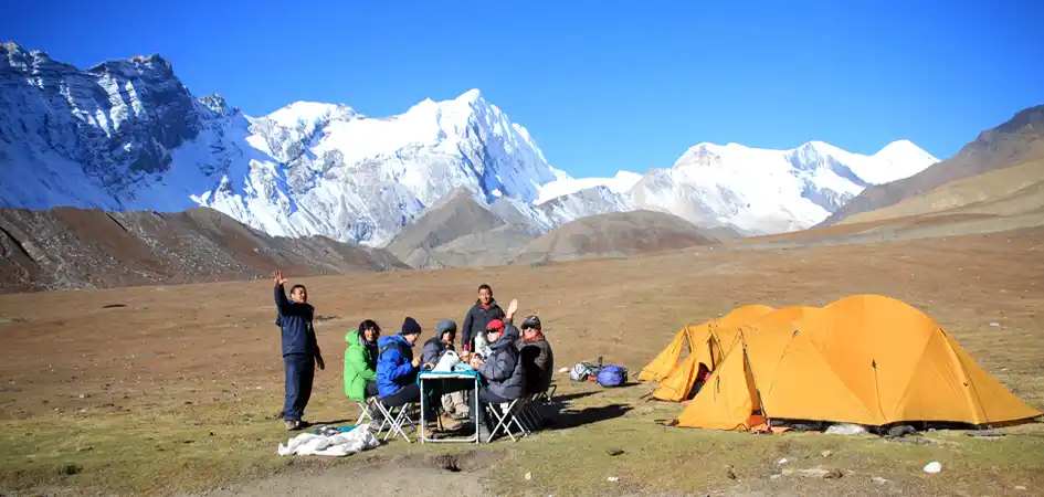
The Manaslu High Passes Trek is one of the most breathtaking trekking adventures in the Manaslu region of Nepal. It offers you an extraordinary journey from the lowland valleys (at an altitude of about 228 meters) to the towering heights near Mount Manaslu (8,163 meters). The remote Himalayan circuit around Manaslu offers dramatic scenery, a rich cultural heritage, and challenging high mountain passes, making it a fantastic choice for experienced trekkers looking for an off-the-beaten-path adventure in Nepal.


Upper Manaslu & Tsum Valley: Culture and Spiritual Himalayan Experience

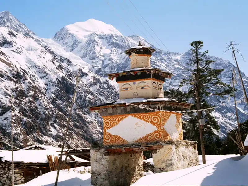
The Manaslu region is divided into two major sections: Upper Manaslu and Tsum Valley and the Lower Manaslu region. The Upper Manaslu and Tsum Valley areas are well-known for their deep cultural roots, old monasteries, and preserved Buddhist heritage. Trekkers experience a special combination of natural beauty and centuries-old traditions preserved by local Himalayan communities. The trek passes through various ethnic groups along the way, each with their set of customs, traditions, and ways of life. The region provides breathtaking views of snow-capped peaks as well as an in-depth understanding of the Himalayas' cultural richness, which combines religion, history, and archaeology.


Dharche Dada – Sacred Viewpoint of Lower Manaslu

Dharche Dada (3,190 meters) is one of the highest and most revered viewpoints in the Lower Manaslu region. It is a sacred place to the local people and has both spiritual importance and breathtaking views of the Himalayas. Dharche Dada offers trekkers breathtaking views of major Himalayan ranges like the following:

  • Ganesh Himal
  • Boudha Himal
  • Sringi Himal
  • Himalchuli
  • Lamjung Himal
  • Annapurna Range

The region is more beautiful in spring with rhododendron forests in bloom. A Himalayan setting alive with colors, ideal for trekking and photography.


Rupina La Pass Trek – Remote Wilderness Adventure in Manaslu

The Rupina La Pass Trek (15,480 feet) is one of the most remote and challenging trekking routes in the Lower Manaslu region. This trail is an adventure in the Himalayas, known for its dramatic scenery and untouched wilderness. The route leads to the remote village of Nyak from Barpak-Laprak. Much of the trail passes through rugged country, with no permanent human settlement. This makes it one of the most pristine treks in Nepal, perfect for trekkers looking for solitude, raw nature, and adventure.


Gyala Pass – Ancient Salt Trade Route in Manaslu Region

The Gyala Pass, at 5,375 meters, is an important trekking trail that has a lot of history, having been a part of the ancient salt trading route between Nepal and Tibet. Located to the north of Samdo in the Manaslu region, this high mountain pass offers panoramic Himalayan views and a strong sense of history and culture. The trail is still relatively little known but rewarding for trekkers interested in natural surroundings and Himalayan heritage.


Larkya La Pass – Highest Point of Manaslu Circuit Trek

The Larkya La Pass (5,106 meters / 16,752 feet) is the highest and one of the most difficult sections of the Manaslu Circuit Trek. Located between Dharmashala and Bimthang, this high-altitude pass is known for its challenging climb and stunning panoramic views of the surrounding Himalayan peaks. Crossing the Larkya La is one of the most rewarding highlights of trekking in Nepal, and it is a major achievement for trekkers.


A Complete Himalayan Trekking Experience

The Manaslu High Passes Trek provides an unmatched combination of adventure, culture, and natural beauty. This trekking route takes you from sacred viewpoints like Dharche Dada to challenging high passes such as Rupina La, Gyala Pass, and Larkya La and displays the very best of the Manaslu region. The Manaslu High Passes Trek is one of the premier trekking expeditions in Nepal for trekkers who seek a remote, less crowded, and profoundly rewarding Himalayan adventure.

Manaslu High Passes Trek Highlights


The Manaslu High Pass Trek is one of Nepal's most challenging and rewarding treks, combining remote wilderness, high mountain passes, and rich Himalayan culture. Here are the main highlights of this epic journey.

  • Diverse Geographical Landscapes: The Manaslu High Passes Trek is an exciting experience for trekkers to move through different landscapes, from low valleys to the eighth-highest mountain in the world.

  • Discovery of Two Principal Areas: The trek offers different landscapes that include historical sites, cultural experiences, and breathtaking mountain views. It is divided into Upper Manaslu, Tsum Valley and Lower Manaslu

  • Experiencing Culture: Trekkers will be able to meet different ethnic groups, learn about and observe their traditions, and visit important places and fascinating archaeological sites while hiking in the Manaslu area.

  • Breathtaking Mountain Views: The trail offers stunning views of snow-capped mountains, including the famous Manaslu. The trip offers plenty of photo ops along with those moments of reflection that come with the Himalayan vista.

  • Dharche Dada: This revered religious site in the area provides trekkers with a spiritual experience amidst a stunning 360-degree mountain panorama.

  • Rupina-La Pass: Located at the foot of the Himalayas, this trekking pass is known for its difficult terrain and breathtaking views. Trekkers can enjoy the area's unspoiled beauty and isolation, as there has been no human presence until Nyak.

  • Gyala Pass: Originally used as a salt trade route between Tibet and Nepal, Gyala Pass is now a popular trekking destination with stunning views of the surrounding area. Trekkers learn about the historical trail's cultural and natural significance as they follow it.

  • Larkya La Pass: The longest trekking pass of the route, Larkya La Pass is a serious obstacle for trekkers. It's a tough pass, but the views are stunning and the sense of achievement is unmatched. It is a very rewarding experience.

  • Less-Crowded Himalayan Trail: Trek one of the most pristine trekking routes in Nepal, away from the crowded tourist trails, offering tranquility, solitude, and unspoiled natural beauty.

  • Blooming Rhododendron Forests: In the spring, the trail is a riot of color, with lush rhododendron blooms blanketing the hillsides.

  • Wildlife and Natural Biodiversity: Experience Himalayan wildlife, including blue sheep, musk deer, and various bird species, in a protected and pristine environment.

  • Authentic Himalayan Villages: Experience the traditional lifestyle in remote villages like Samdo, Bhimthang, and Nyak, where ancient traditions survive.

  • Rich Tibetan-Inspired Culture: Explore ancient Buddhist monasteries, prayer flags, mani walls, and traditional villages with Tibetan influences, especially in the Upper Manaslu and Tsum Valley areas.

  • Ultimate Adventure Experience: The trek is for the seasoned trekker, who seeks high-altitude challenges, cultural immersion, and off-the-beaten-path exploration.


Trip Itinerary

Day 01: Arrive in Kathmandu

Upon your arrival in Kathmandu, Nepal, a friendly representative from Manaslu Trek will greet you at the airport and escort you to your hotel. This marks the beginning of your Manaslu Four High Passes Trek adventure, offering a smooth and comfortable start to your journey in the Himalayan region.

In the evening, we host a special welcome dinner featuring authentic Nepalese cuisine, accompanied by a refreshing reception drink. This welcome evening also provides an opportunity to meet your fellow trekkers, discuss the Manaslu Four High Passes Trek itinerary, and receive essential tips for trekking in the Himalayas, including acclimatization, packing, and safety advice. Starting your journey in Kathmandu allows you to ease into the adventure while enjoying the city’s vibrant culture and setting the stage for your unforgettable Himalayan trekking experience.

Transfer: 30-45 min | Accommodation: Hotel | Meal: Welcome Dinner

Day 02: Full day City Tour in Kathmandu

Today, explore the rich culture, history, and heritage of Kathmandu Valley on this full-day city tour before your Manaslu Four High Passes Trek. The tour takes you to some of Kathmandu's most famous UNESCO World Heritage Sites, offering a perfect introduction to Nepalese art, architecture, and traditions with our professional English-speaking City Tour Guide:

  • SWOYAMBHUNATH , also known as the Monkey Temple, is one of Kathmandu Valley’s most iconic Buddhist stupas. Perched on a hilltop, it offers panoramic views of Kathmandu city and features ancient shrines, prayer wheels, and intricate carvings. The site is a spiritual and cultural landmark, attracting both pilgrims and tourists.
  • KATHMANDU DURBAR SQUARE is a UNESCO World Heritage Site and the historic heart of Kathmandu City. Known for its ancient palaces, temples, courtyards, and intricate wood carvings, it reflects Nepalese art, culture, and architecture. A visit to this iconic square offers a glimpse into the royal history of Nepal.
  • BOUDHANATH STUPA is one of the largest and most important Buddhist stupas in Nepal and a UNESCO World Heritage Site. Known for its massive white dome, colorful prayer flags, and iconic Buddha eyes, it serves as a major center for Tibetan Buddhism. Visiting Boudhanath provides an immersive cultural and spiritual experience.
  • PASHUPATINATH is one of Nepal’s most sacred Hindu temples, dedicated to Lord Shiva and located on the banks of the Bagmati River in Kathmandu. Famous for its intricate pagoda-style architecture, cremation ghats, and spiritual rituals, it offers visitors a deep cultural and religious experience.

Our knowledgeable guide will tell you interesting things about the religious, historical, and architectural importance of each landmark. Kathmandu is a unique city with a rich culture and a spiritual atmosphere that will make your city tour an interesting and memorable way to learn about Nepalese heritage.

Sightseeing: 7-8 Hours | Accommodation: Hotel | Meal: Breakfast

Day 03: By Bus: Kathmandu to Ghyampesal (950 m)

After breakfast in Kathmandu, the drive begins, unfolding in three distinct phases, beginning with a drive from Kathmandu to Mugling via Thankot, where the road descends through winding valleys to join the Prithvi Highway alongside the Trishuli River, with views of cable cars heading to Manakamana Temple; early morning departure is recommended to avoid heavy traffic. From Mugling, the route turns at Abu Khaireni toward Gorkha Bazaar, climbing through terraced hillsides to reach the historic town overlooked by the Gorkha, an ideal stop for a traditional Thakali lunch. The final stretch from Gorkha to Ghyampesal is more rugged, featuring a mix of rough roads, switchbacks, and occasional muddy sections while offering rich cultural encounters in Magar and Gurung villages and, on clear days, expanding views of the Manaslu and Ganesh Himal ranges before arriving at Ghyampesal, a key gateway to the Lower Manaslu Trek.

Transfer: 170 km, 6-8 hours |  Accommodation: Hotel l Meal: Breakfast, Lunch, Dinner

Day 04: Ghyampesal to Thotneri (1,735m)

Starting from Ghyampesal, you begin your journey by driving uphill through forested hills and terraced farmland, making sure to carry enough fuel and supplies because services become limited ahead. The road climbs steadily to Deurali, where the air becomes cooler and you get wide views over deep valleys and traditional hill villages. From there, you continue along a scenic ridge toward Mulbari, passing fields of maize and millet and resting spots under banyan trees where locals gather. The route then descends into the more rugged area of Tamakhani, historically known for copper mining, where the landscape becomes rockier and more dramatic, with a favorable chance to stop for food and tea in a quiet village setting. Finally, you make the last winding descent to Thotneri, a peaceful settlement surrounded by green hills and terraced farms, marking the end of the journey through this remote and culturally rich part of Gorkha.

Transfer: 30 km, 3-5 hours |  Accommodation: Tent l Meal: Breakfast, Lunch, Dinner

Day 05: Cross Dharche Dada (3,200m). Trek to Gupsi Pakha (2,750m)

Starting from Thotneri, you begin a steep and steady climb through terraced fields and oak-rhododendron forests until you reach Dharche Danda (3,195m), a sacred hilltop with prayer flags and a small shrine where the entire Himalayan range opens up in every direction, including views of the Annapurna range to the west, Mount Manaslu to the north, and Ganesh and Shringi Himal to the east. From the summit, the trail continues along a high ridge through open grazing lands, passing peaceful pastures like Sumbai Kharka and Nambai Kharka, where herders bring livestock, and the landscape becomes grassy, windy, and dotted with wildflowers in spring. After enjoying the ridge walk, you descend gently toward Gupsi Pakha (2,750m), a wide grassy viewpoint considered one of the most scenic spots in Gorkha, where you can watch sunset light up the Manaslu range in golden and purple colors, making it a perfect place to end the day.

Trekking: 7-9 Hours | Altitude Gain: 1,465 m | Altitude Loss: 450 m | Accommodation: Tent l Meals: Breakfast, Lunch, Dinner

Day 06: Gupsi Pakha to Humche Dada (3,000m)

After breakfast in Gupsi Pakha, the trek begins with a steady climb through a beautiful forest of rhododendron and oak trees, especially colorful in spring when red and pink flowers bloom. As you walk, you may hear birds and even spot the bright Himalayan monal. After about two hours, the forest opens up to narrow ridges, where the trail becomes more dramatic with wide mountain views of Baudha Himal (6,672m) and Peak 29 (Ngadi Chuli) to the north. The path can be narrow and a bit slippery in fog, so careful walking is needed. The final part of the trek follows gentle highland pastures, where the air feels thinner and you may see simple stone shelters used by local shepherds. Upon reaching Humche Dada, you are rewarded with a beautiful ridge campsite offering amazing panoramic views of Baudha Himal, Sringi Himal, Ganesh Himal, and even the distant Annapurna range, making it a perfect mix of nature, peace, and high-mountain adventure.

Trekking: 3-4 Hours | Distance: 8 km | Altitude Gain: 570 m | Altitude Loss: 170 m | Accommodation: Tent l Meals: Breakfast, Lunch, Dinner

Day 07: Humche Dada to Ruse Kharka (2,835m)

Leaving the campsite at Humche Dada, the day begins with a stunning ridge walk offering clear views of Ganesh Himal to the east and the towering Baudha Himal ahead, though the exposed trail can be cold and windy in the early morning. The path then descends steeply into a more remote and wild section, following narrow, sometimes faint trails through tall grass and bamboo, with loose rocks requiring careful footing. As you descend, the landscape changes from open alpine terrain to dense forest, passing through juniper, bamboo, and rhododendron. Along the way, you cross several small streams that feed into the Daraudi River, which may need extra care depending on the season. The trek continues through quiet valleys and green surroundings, where you might see grazing areas and simple shelters used by local herders. Upon reaching Ruse Kharka (2,835m), you arrive at a peaceful pasture surrounded by wilderness, with a few stone huts and a calm atmosphere, making it a perfect spot for an authentic and remote camping experience in the Himalayas.

Trekking: 4-5 Hours | Distance: 7 km | Altitude Gain: 430 m | Altitude Loss: 390 m | Accommodation: Tent l Meals: Breakfast, Lunch, Dinner

Day 08: Ruse Kharka to Rupina La Phedi (3825m)

After breakfast in Ruse Kharka, the trek begins with a steady climb out of the basin, passing through high-altitude vegetation where tall Himalayan fir and twisted rhododendron trees slowly give way to dwarf juniper and hardy alpine shrubs. The trail can be damp and muddy in places as it follows the upper streams that feed the Buri Gandaki River. As you rise above the treeline, the landscape opens into a wide alpine tundra surrounded by dramatic mountain scenery, with the massive south faces of Baudha Himal (6,672m) and Ngadi Chuli (7,871m) dominating the skyline. The path becomes more rugged and rocky as it crosses old glacial moraines, often marked with stone cairns that help guide the way in misty conditions. After descending to the small stream of Sumrung Khola and climbing again, you reach Rupina La Phedi (3,825m), the base camp below the pass. This windswept, rocky campsite sits at the head of a glacial valley and offers raw Himalayan beauty, where trekkers set up tents carefully against the strong mountain winds and enjoy a peaceful night surrounded by dramatic high-altitude landscapes.

Walk: 5-6 hours |  Distance: 7 km | Altitude Gain: 910 m |  Altitude Loss: 130 m | Accommodation: Tent l Meals: Breakfast, Lunch, Dinner

Day 09: Cross Rupina La Pass (4,610m). Trek to Thadepuk (3,600m)

The day starts very early, around 4:00 AM, to cross Rupina La (4,610m) before strong winds and soft snow make the descent more difficult. From the Phedi, the climb is steep and challenging, with loose rocks, glacial debris, and often hard snow or ice, so microspikes or crampons can be helpful. The trail is not always clear, marked only by small stone cairns, and you may need to scramble over large boulders as you gain height. The final section is the steepest, leading to the pass decorated with prayer flags, where you are rewarded with incredible views of Baudha Himal, surrounding glaciers, and distant peaks of the Sringi, Khutang, and Ganesh Himal ranges. The descent is tough and requires caution, starting with steep snowy or icy slopes, followed by loose rocky terrain and a narrow valley with high cliffs and hanging glaciers. One steep scree section is especially demanding. After the difficult descent, the trail becomes easier as it follows the edge of the Chuling Glacier, crossing small streams and alpine wetlands on the way to Thadepuk. This high-altitude pasture offers a simple but beautiful campsite, where you can rest and enjoy the wild Himalayan surroundings, and with some luck, spot blue sheep on the nearby cliffs.

Trekking: 6-7 Hours |  Distance: 6 km |  Altitude Gain: 710 m |  Altitude Loss: 730 m | Accommodation: Tent l Meal: Breakfast, Lunch, Dinner

Day 10: Thadepuk to John kharka (3,100m)

Leaving the open meadows of Thadepuk, the trail follows the glacier’s side moraine, with early morning light shining on the huge ice walls of Baudha Himal behind you. The path is rough and unstable in places, with loose rocks and small streams that must be crossed carefully. One of the hardest parts of the day is the steep descent toward Reul Khola, where the trail is often unclear, and you may need to walk along the riverbed over large boulders or climb higher along the valley sides to avoid narrow sections. As you drop below 3,500m, the scenery slowly changes from cold alpine terrain to green forest, with juniper giving way to thicker shrubs, birch, fir, and beautiful rhododendron and hemlock forests. This area is also home to wildlife such as musk deer and Himalayan tahr. The trail continues east toward the Budhi Gandaki valley, with increasing views of Ganesh Himal and glimpses of glaciers like Rupina La and Baudha Himal along the way. After a mix of ups and downs, the day ends at John Kharka (Zakbathan), a peaceful grassy campsite near the meeting point of Reul Khola and smaller streams, where the sound of flowing water and forest creates a calm and relaxing place to rest after a challenging day in the mountains.

Trekking: 6-7 Hours | Distance: 10 km |  Altitude Gain: 130 m |  Altitude Loss: 940 m | Accommodation: Tent l Meals: Breakfast, Lunch, Dinner

Day 11: John Kharka to Nyak (2280m)

After breakfast in John Kharka, the trail descends along the western bank of the Reul Khola through one of the most beautiful and untouched forest sections in the Gorkha region. Tall Himalayan hemlock, fir, and maple trees form a dense green canopy, while rhododendron, moss, and pine needles cover the forest floor, creating a peaceful atmosphere with the sound of the river flowing below. As the valley becomes narrower, the trail climbs higher along steep cliffs and narrow paths carved into the hillside, with dramatic drop-offs and wide views of where the turquoise Reul Khola meets the grey waters of the Buri Gandaki, marking the end of the remote Rupina La wilderness.

After a steep descent, the trail joins the main Manaslu Circuit route near suspension bridges over the Buri Gandaki, where the return to busier trekking paths feels very different after days of isolation. From the riverbank, a strong 45–60-minute climb leads up to Nyak, a traditional Gurung village sitting on a wide mountain terrace. The village is known for its stone houses, wooden roofs, terraced fields of barley, buckwheat, and potatoes, and cultural landmarks like mani walls and chortens, showing the transition from lower Gurung culture to the Tibetan-influenced heritage of the upper Manaslu region.

Trekking: 7-9 Hours | Distance: 15 km | Altitude Gain: 580 m |  Altitude Loss: 2,370 m | Accommodation: Lodge I Meals: Breakfast, Lunch, Dinner

Day 12: Nyak to Prok (2,397m)

After breakfast in Nyak, the trek begins with a steep descent through rocky switchbacks down to the Buri Gandaki River. This section follows one of the narrowest parts of the valley, where the trail is often cut into cliffs or supported by wooden beams, with the river rushing far below. Near Pewa, a small riverside settlement, the trail splits; instead of continuing toward Deng, you cross to the western bank to start the climb toward the hidden Prok plateau.

From the river, the trail enters a quiet forest of Himalayan blue pine and hemlock, filled with fresh mountain air, waterfalls, and birdlife, with a chance to see langur monkeys along the way. The final section is a steady uphill climb to Prok, where traditional stone gates (Kani) and carved mani walls mark the village entrance and are passed clockwise as a sign of respect. Prok is a peaceful traditional village set on a wide plateau, surrounded by fields of barley, buckwheat, and potatoes, and offering beautiful sunset views of Sringi Himal (7,161 m), which often glows golden and orange in the evening light.

Trekking: 5-6 Hours |  Distance: 14 km |  Altitude Gain: 1,020 m |  Altitude Loss: 900 m | Accommodation: Lodge I Meals: Breakfast, Lunch, Dinner

Day 13: Hike to Kalchhuman Lake/Kaal Taal(3,685m) and Kal Chhokang Gompa

Starting from Prok Village, you begin your hike after breakfast, walking uphill through a thick forest of pine, rhododendron, and cedar trees. The climb is steep and challenging, gaining over 1,000 meters. On the way, you reach Kal Chhokang Gompa, a quiet and peaceful monastery with beautiful views of the Sringi Himal and the Budhi Gandaki valley. Continuing, the trail becomes easier as you enter a high glacial basin and reach Kalchhuman Lake (3,685m), a calm, beautiful lake surrounded by mountains and glaciers, known locally as “Kaal Taal.” After enjoying the peaceful surroundings, you return the same way back to Prok, where traditional stone houses and village life give a more authentic experience than busier places. Since there are no shops or tea houses along the route, it is important to carry enough water and a packed lunch.

Trekking: 7-9 Hours |  Distance: 12 km |  Altitude Gain: 1,300m |  Altitude Loss: 1,300 m | Accommodation: Lodge I Meals: Breakfast, Lunch, Dinner

Day 14: Prok to Lho (3,180m)

After breakfast in Prok, the trail descends through moss-covered forests toward the Buri Gandaki River, passing a narrow shaded gorge filled with ferns and hanging moss. A suspension bridge then crosses the river back to the eastern bank, offering a dramatic view of Prok perched high above the valley. From here, the trail climbs steadily to Namrung (2,630m), a key checkpoint where permits are checked. Namrung is a traditional stone village with colorful entrance gates (kanis), designed to protect against cold winds, and it offers views of Sringi Himal behind and the first clear sight of the Manaslu range ahead.

Beyond Namrung, the valley opens up and becomes more fertile as you pass through Lihi (2,900m) and Sho (3,000m), villages known for terrace farming, chortens, and long lines of Mani stones carved with “Om Mani Padme Hum.” Between these villages, you can enjoy views of Ngadi Chuli (Peak 29) and the lower slopes of Manaslu, while passing locals in traditional chuba clothing and seasonal orchards of apples and apricots. The final section climbs through pine forest to Lho (3,180m), a beautiful village with one of the best views of Mount Manaslu (8,163m), rising above the hillside monastery. Ribung Monastery, located above the village, is its spiritual heart, where the sound of chanting and cymbals often fills the valley in the evening.

Trekking: 7-9 Hours | Distance: 18 km |  Altitude Gain: 1,160 m |  Altitude Loss: 400 m | Accommodation: Lodge l Meals: Breakfast, Lunch, Dinner

Day 15: Lho to Samagaon (3,525m)

After breakfast in Lho, the day begins with an early sunrise view of Mount Manaslu, where the first light turns the peaks golden while monks at Ribung Monastery perform their morning prayers. The trail then leaves Lho and passes through rhododendron and pine forests, crossing a small stream before reaching the ridge village of Shyala (3,500m), which offers wide panoramic views of Manaslu, Himal Chuli, Ngadi Chuli, and Ganesh Himal in the distance. From Shyala, there is an optional and challenging side trip toward the Pungyen Glacier and Pungyen Gompa, where the landscape becomes completely alpine with no trees, only rocks, glaciers, and dramatic views of Manaslu’s ice walls; the rebuilt monastery here is quiet and powerful, with occasional sounds of ice breaking from the glacier. After returning to the main trail, you continue across open alpine terrain and grazing areas, passing the junction for the Pungyen route before gradually descending into the wide valley floor. The route then leads into Samagaon through long mani walls and cultivated fields of barley and potatoes. Samagaon is the cultural heart of the region, a large traditional Tibetan-influenced village with stone houses, yaks, and a strong Buddhist heritage, where people maintain trade links with Tibet over nearby high passes and continue traditional weaving and farming. It is an important place for rest and acclimatization, and you can spend the afternoon exploring the village, old monasteries, and surrounding viewpoints.

Trekking: 7-8 Hours |  Distance: 17 km |  Altitude Gain: 970 m |  Altitude Loss: 630 m | Accommodation: Lodge l Meals: Breakfast, Lunch, Dinner

Day 16: Acclimatization day

Today is an acclimatization day in Samagaon, giving us time to rest, adjust to the altitude, and prepare for the days ahead. We have two great options: a short and easy hike to Birendra Tal (3,691 m) or a more challenging trek to Manaslu Base Camp (4,800 m). The walk to Birendra Tal takes about 45 minutes to an hour on a mostly flat trail, passing mani walls and chortens along the Manaslu Glacier, leading to a peaceful, emerald-colored lake surrounded by ice cliffs, where you may hear distant avalanches. Many people return from here, but if we continue to Base Camp, the trail becomes steep and demanding, climbing over 1,200 meters in 4–5 hours. The path goes through rocky terrain with less vegetation and thinner air, making the walk slower and more tiring. However, the reward is incredible, with close views of Mt. Manaslu and nearby peaks like Himalchuli and Ngadi Chuli, along with the large Manaslu Glacier below—making it a truly unforgettable experience.

Hiking: 7-8 Hours |  Distance: 15 km |  Altitude Gain: 1,320 m |  Altitude Loss: 1,320 m | Accommodation: Lodge l Meals: Breakfast, Lunch, Dinner

Day 17: Samagaon to Samdo (3,690m)

After breakfast in Samagaon, the trek follows the upper Budi Gandaki River as the green landscape slowly changes into dry alpine terrain, passing through birch and juniper trees before opening into rocky ground with small bushes. As the valley widens, you can enjoy wide views of Mount Manaslu (8,163 m) on the left and the rugged mountains near the Tibetan border on the right, while walking past mani walls and chortens, always keeping them on your left. Along the way, you pass the long mani walls at Kermo Kharka, then cross a small wooden bridge and climb gently to reach Samdo in about 3–4 hours, usually in time for lunch. The village appears as a group of stone houses under a rocky hill, marked by an entrance chorten and a “kane” gateway. After arrival, you can visit a small home gompa where local lamas perform prayers. In the afternoon, you can take an acclimatization hike above the village toward Samdo Peak, walking slowly on a steep and rocky trail in thin air, reaching viewpoints up to around 5,177 m. From there, you can see amazing views of Manaslu’s glaciers, Rani Peak, the route toward Rui La (4,998 m) and even the distant Tibetan plateau, along with glacial valleys and frozen lakes below.

Trekking: 3-4 Hours |  Distance: 8 km |  Altitude Gain: 360 m | Altitude Loss: 10 m | Accommodation: Lodge I Meal: Breakfast, Lunch, Dinner

Day 18: Hike to Rui La Pass (4,998m). Overnight Yak Kharka (4,200m)

Leaving the remote village of Samdo early in the morning, you follow a quiet northern trail up the Pana Danda Valley toward Rui La, a steady and demanding ascent through dry, windswept high-altitude terrain of scree and barren slopes. At the pass, marked by Border Pillar 35, the dramatic contrast unfolds between the towering Himalayan peaks behind—featuring views of Mount Manaslu, the Fukang Glacier, and the Syaula Peaks—and the vast, rolling expanse of the Tibetan Plateau ahead. After taking in the scenery, you descend steeply along the same valley before traversing across slopes toward the quieter grazing grounds of Yak Kharka, a peaceful pasture area dotted with stone herder shelters and grazing yaks.

Trekking: 7-9 Hours |  Distance: 13 km |  Altitude Gain: 1,150 m | Altitude Loss: 600 m | Accommodation: Tent I Meal: Breakfast, Lunch, Dinner

Day 19: Excursion to Gyala La Pass (5,375m). Overnight in Gyala Phedi (4,530m)

Starting before dawn from Yak Kharka, you head north into a remote high-altitude wilderness, leaving the main Manaslu Circuit behind as the first light paints Mount Manaslu and Peak 29 in deep crimson hues above the upper Budhi Gandaki. The trail climbs steadily through a stark transition zone where vegetation disappears beyond 4,800 meters, replaced by a harsh trans-Himalayan desert of boulders and glacial moraines, with thin air making every step slow and deliberate. After a grueling ascent, you reach Gyala La Pass (5,375m), where the landscape dramatically opens—northward to the vast Tibetan Plateau and southward to the jagged Himalaya skyline and the intricate ice formations of the Fukang Glacier, with ancient cairns and prayer flags hinting at its history as an old trade route. From the pass, a careful and steep descent over loose scree leads down to Gyala Phedi (4,530 m), a remote and austere bivouac site that offers solitude and serves as a demanding challenge.

Trekking: 8-10 Hours |  Distance: 14 km |  Altitude Gain: 1,175 m | Altitude Loss: 845 m | Accommodation: Tent I Meal: Breakfast, Lunch, Dinner

Day 20: Gyala Phedi to Dharamshala (4,460m)

The day starts with an easy downhill walk from Gyala Phedi (4,530m), following a small glacial stream as the landscape slowly becomes greener again, bringing you back to Samdo (3,875m), where you can rest, eat, and refill supplies. From Samdo, you head west, cross the Budhi Gandaki River, and pass the old ruins of Larke Bazaar, once a busy trading place. The trail then climbs gently to Yak Kharka, a wide pasture where yaks graze, with great views of Mount Manaslu. Finally, you continue on a rough, rocky path along the glacier’s edge to reach Dharamsala (4,460m), a simple high camp where trekkers stay before crossing Larkya La early the next morning.

Trekking: 6-8 Hours |  Distance: 14 km |  Altitude Gain: 520 m | Altitude Loss: 540 m | Accommodation: Lodge I Meal: Breakfast, Lunch, Dinner

Day 21: Cross Larkya La Pass (5,106m). Trek to Bhimtang (3,590m)

The day starts very early around 3:00 AM in the cold darkness of Dharamsala (Larke Phedi), where trekkers wake up in freezing temperatures of around -10°C to -15°C to cross Larke Pass before strong afternoon winds begin. The first part of the trek is a slow and steady climb over frozen scree and icy paths along the Larke Glacier moraine, moving at a careful, rhythmic pace in the dark with headlamps, passing small prayer flags and frozen lakes along the way. As the sun slowly rises over the surrounding Himalayan peaks, the final ascent becomes more visible, with thin air making every step harder and more deliberate. After hours of climbing, you reach Larkya La Pass at 5,106 m, marked by colorful prayer flags and surrounded by breathtaking views of peaks like Himlung Himal, Cheo Himal, Kang Guru, Gyaji Kung, and even distant Annapurna II, making it a truly rewarding moment.

From the pass, a very steep and long descent begins, which is physically tough on the knees as you walk down loose scree and sometimes snowy paths toward the valley below. The trail then follows the edge of the glacier moraine before gradually entering greener landscapes, where rocky ground turns into grass, shrubs, and finally beautiful alpine forests. After hours of downhill trekking, you arrive at Bhimtang at 3,720 m, a wide and peaceful valley surrounded by glaciers and mountains. Here, the tea houses feel warm and welcoming after a long day, and the incredible views of the Manaslu West Face and surrounding peaks make the effort of crossing the pass completely unforgettable.

Trekking: 7-9 Hours |  Distance: 16 km |  Altitude Gain: 680 m | Altitude Loss: 1,450 m | Accommodation: Lodge I Meals: Breakfast, Lunch, Dinner

Day 22: Bhimtang to Gowa (2,515m)

After breakfast in Bhimtang, the day begins with stunning views of Manaslu’s West Face and nearby peaks before you leave the sandy glacial basin and cross the moraine of the Bhimtang Glacier. Soon, the trail enters beautiful forests of rhododendron, pine, birch, and moss-covered trees that feel magical, especially in spring when the ground is covered with red, pink, and white flowers. As you descend further along the Dudh Khola, the air becomes warmer and easier to breathe. The first stop is Chauli Kharka, a wide pasture where yaks graze and trekkers take a short break, followed by Surki Kharka, where the forest becomes thicker, greener, and full of bird sounds. The trail then continues down to Karche, a peaceful village on a river terrace where it is a good place for lunch with dramatic views of the gorge below. After a short climb over a ridge, the path gently descends through terraced fields and farming villages, where you can see local life more clearly. Finally, you reach Gowa, a quiet agricultural village surrounded by barley, wheat, and potato fields, where the air is warm and comfortable, and teahouses offer a relaxing end to the day with hot showers and a sense of achievement after the high mountains.

Trekking: 5-6 Hours |  Distance: 14 km |  Altitude Gain: 50 m  |  Altitude Loss: 1,240 m | Accommodation: Lodge l Meals: Breakfast, Lunch, Dinner

Day 23: Gowa to Tal (1,700m)

After breakfast in Gowa, the trek begins with a gentle downhill walk through green, fertile farmland and villages, where the air feels rich in oxygen, and the smell of woodsmoke and fresh earth replaces the cold mountain air. After about 1.5–2 hours, you reach Tilche, a large and traditional Gurung village with stone houses, paved paths, and a more permanent settlement feel. Around Tilche, you can see apple orchards and may also pass a police checkpost where trekking permits are officially stamped for the last time. From here, the trail descends toward the river and crosses a long suspension bridge over the Dudh Khola before climbing up to Dharapani. At this important junction, the Manaslu Circuit meets the Annapurna Circuit. In Dharapani, the atmosphere becomes busier, with more trekkers, better facilities, and official permit checks for the Annapurna Conservation Area. After lunch, the trail continues along the Marsyangdi River through a deep gorge with cliffs and waterfalls, sometimes following the old walking trail to avoid the nearby road. Finally, the valley opens up as you arrive at Tal, a beautiful village on a flat sandy valley floor with a large waterfall nearby, marking a warm and scenic end to this trekking section.

Walk: 5-6 Hours  | Distance: 17 km | Altitude Gain: 140 m  |  Altitude Loss: 990 m | Accommodation: Lodge l Meals: Breakfast, Lunch, Dinner

Day 24: Drive back to Kathmandu by Jeep

After breakfast in Tal, the drive begins with an exciting off-road jeep ride down the Marsyangdi Valley, where the road is carved into cliffs, and the river flows far below. Along the way, you pass villages like Chamje and Jagat, with waterfalls often splashing onto the road, and make a dramatic descent near Syange, where the huge waterfall marks your final view of the high mountains. As you go lower toward Besisahar, the cold alpine air turns warm and humid, and pine forests slowly change into banana trees, bamboo, and green rice fields. Besisahar is a busy town and the main gateway of the region, where many trekkers change from jeep to car or bus and enjoy their first proper “city-style” meal after days in the mountains. From here, the drive continues along the Prithvi Highway through the wide Marsyangdi Valley, passing hydropower projects and eventually reaching Mugling, a busy road junction at the meeting point of the Marsyangdi and Trishuli rivers, known for its heavy traffic, roadside restaurants, and river fish. The final stretch follows the Trishuli River, where you may see white-water rafting and winding roads through green hills before climbing up through Naubise toward Thankot. Finally, you enter Kathmandu Valley, where the mountains fade behind you and the landscape opens into a wide valley filled with houses, temples, and the busy capital city, marking the end of your Himalayan journey.

Transfer: 215 km, 8-10 Hours |  Accommodation: Hotel l Meal: Breakfast, Lunch

Day 25: Free day in Kathmandu for self shopping

Today, we have a free day to explore the vibrant city of Kathmandu on our own. You may want to spend the day indulging in some souvenir shopping, wandering around the colorful streets and bazaars, or enjoying the local cuisine. You could also visit some of the popular tourist attractions in the city, such as Bhaktapur or Patan, which showcase Nepal's rich cultural and historical heritage. Alternatively, you could engage in other activities like hiking, biking, or adventure sports, or simply relax and rejuvenate in one of the city's many spas and wellness centers. Whatever you choose to do, make sure to soak up the unique sights, sounds, and flavors of this wonderful city.

Accommodation: Hotel l Meal: Breakfast

Day 26: Transfer to Kathmandu International airport for departure

Today, we will transfer to Kathmandu International Airport for our departure. After enjoying a hearty breakfast at the hotel, we will gather our belongings and make our way to the airport. We will ensure that we reach the airport well in time to complete all the necessary formalities and board our flight. Before we bid farewell to this enchanting country, take one last look at the breathtaking views of the Himalayas and take a moment to appreciate the warm hospitality and kindness of the Nepalese people. This marks the end of our tour, and we hope you had a memorable and enjoyable time in Nepal.

Meal: Breakfast

Cost & Dates

Manaslu High Passes Trek cost on the website applies to 6-12 people groups. However, private trips for groups of two or more can be organized upon request. A group booking of 12 or more people can avail of a maximum discount with one free trip. Clients' travel date preferences can be accommodated, but the trek cost depends on factors such as group size, duration, accommodation type, and additional activities or services.

  • Group Size: The cost of the trip will depend on the size of the group.
  • Hotel Accommodation Category and Client's Budget: The cost may also vary based on the accommodation category and budget preference of the client.
  • Itinerary Modification: Our trekking itinerary can be modified according to your time and requirements, and the cost will be adjusted accordingly.
  • Additional Services: If you require additional services, the cost will be adjusted accordingly based on mutual understanding.
  • Trekking Staff: The cost is also affected by the number of Trekking Guides, Assistant Guides, and extra porters required for the trip.
Please feel free to reach out to us with any questions or to book your trek.

Cost Includes:

  • Airport pick up and drop services in private transportation before and after the trek.
  • 4 Nights 3-Star accommodation in Kathmandu at twin sharing a room on BB plan.
  • City Cultural Tour in Kathmandu with City Tour Guide and all the entrance and monument fees.
  • Transportation: Kathmandu - Gyampesal and Dharapani- Kathmandu.
  • Accommodation: Twin sharing tents, camping equipment,Kitchen equipment Mattress, Toilet tent, shower, Dinning tent, dining tables, chairs, etc during Manaslu High Pass Trek.
  • Completely camping trekking with full board i.e. breakfast, lunch, and dinner.
  • Experienced English-speaking, Assistant Guide for a group of over 6 people and Porters (2:1) including their daily allowance, meal and accommodation.
  • Assisted by Porters with their lodging, food, and their salary, and insurance for all staff.
  • Accidental and medical insurance for Nepalese team.
  • Special permit of Manaslu Manaslu Conservation Area Project (MCAP) and Annapurna Conservation Are Project (ACAP) Entry Permit fee.
  • Necessary documentation, all government taxes, and agency service charge.

Trip FAQ

Q: What is the Manaslu High Pass Trek?

A: The Manaslu High Pass Trek is an adventurous trek that covers a wide range of geographical terrains from its lowest point to the world's eighth-highest mountain. The trek provides stunning views of snow-capped mountains and an opportunity to interact with different ethnic groups and their cultures and traditions.


Q: How long is the Manaslu High Pass Trek?

A: The Manaslu High Pass Trek is typically completed in 16-20 days, depending on the itinerary and acclimatization schedule.


Q: What is the best time to go on the Manaslu High Pass Trek?

A: The best time to go on the Manaslu High Pass Trek is in the spring (March to May) and autumn (September to November) when the weather is dry, and the skies are clear.


Q: What is the difficulty level of the Manaslu High Pass Trek?

A: The Manaslu High Pass Trek is a challenging trek that requires a good level of fitness and endurance. It involves crossing high mountain passes and trekking through rugged and remote terrain.


Q: Is a permit required for the Manaslu High Pass Trek?

A: Yes, a permit is required for the Manaslu High Pass Trek. The trek falls under the restricted area, and a special permit is required, which can only be obtained through a registered trekking agency.


Q: What kind of accommodation is available on the Manaslu High Pass Trek?

A: The accommodation on the Manaslu High Pass Trek ranges from basic teahouses to more comfortable lodges. The lodges provide basic facilities such as a bed, a blanket, and a pillow. The teahouses provide communal dining areas and shared bathrooms.


Q: What are the highlights of the Manaslu High Pass Trek?

A: The highlights of the Manaslu High Pass Trek include stunning views of snow-capped mountains, an opportunity to interact with different ethnic groups and their cultures and traditions, crossing high mountain passes, and a rare combination of historical, archaeological, religious, and cultural aspects of different ethnic communities.

Most Popular

Manaslu Trekking Tours

Manaslu Circuit Trek
19 Days

The Manaslu Circuit Trek is a beautiful and remote trip around Mount Manaslu (8,163 m), the eighth highest mountain in the world. It has the perfect mix ...

Discover More
Tsum Valley Trek
19 Days

The Tsum Valley Trek is a unique and off-the-beaten-path trekking experience in Nepal’s Manaslu region, known for its rich Tibetan Buddhist culture, ...

Discover More
Lower Manaslu Trek
18 Days

The Lower Manaslu Trek is a beautiful and culturally rich trip in Nepal that lets you see the Himalayas without going too high. This unusual trek takes ...

Discover More
Manaslu Four High Passes Trek
26 Days

The Manaslu High Passes Trek is an adventurous, off-the-beaten-path trek in the Himalayas that circumnavigates the remote Manaslu region, crossing four ...

Discover More